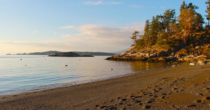
Tunstall Bay is a sandy and rocky beach known for its sunsets. It was originally a retirement community in the 1950s, now it is a popular beach for swimming, kayaking, or sailing. Washrooms are available.
Sunbathe and admire the shimmering green-blue ocean waters, or watch kids taking sailing lessons and kayakers paddling around the island. Bowen residents rave about the awe-inspiring sunsets that can be seen at Tunstall Bay.
WATER QUALITY:
Sampling results from Tunstall Bay have not exceeded Health Canada's guideline values for primary water use at all in the last two years (200 E.coli bacteria/100 ml)
FIRST NATIONS PLACENAME:
The name for Bowen Island in the Squamish language is Nexwlélexwm meaning “fast drumming ground". It was named this because deer were so abundant on Bowen Island, and the name reflected the sound their hooves would make when running. On Nexwlélexwm, the Squamish established a tiny village called Qole’laqom and here they hunted, fished or stopped over during long voyages up and down the coast.
Watch this video to learn how to say Nexwlélexwm - https://youtu.be/jWOpr6wtaUI
FIRST NATIONS HISTORY:
Bowen Island, Nexwlélexwm, is part of the ancestral and unceded territory of the Squamish Nation.
The island was not used as a permanent settlement ground. It was mainly used instead as a stopping ground on long journeys up and down the coast. The island also provided food and sustenance such as deer, salmon, and smelts herring, and therefore it also easily became a seasonal hunting ground.
It was well known to the Squamish that the strong fresh water influence of the Squamish River caused most clams to lodge themselves in Tunstall Bay, that could otherwise not be found anywhere else in the Howe Sound. For this reason, many Squamish people found themselves making camp at or near Gibson’s Landing.
First Nations Information From:
https://howesound.wordpress.com/2020/07/14/bowen-island-nexwlelexwm/
https://bowenislandmuseum.ca/first-nations-on-bowen/
https://www.bowenheritage.org/a-short-history-of-bowen-island.html
Keep your distance from other people.
Practicing social distancing is still essential. Only go to the beach if you are able to keep 6 feet or 2 meters away from others. Follow the instructions provided by your local health authorities. If your community has asked that you remain indoors and away from others, do so. Spending a day in any crowded place is the worst thing we can do for our most vulnerable right now and will counter our efforts to curb the virus’s spread.
Tunstall Bay is a sandy and rocky beach known for its sunsets. It was originally a retirement community in the 1950s, now it is a popular beach for swimming, kayaking, or sailing. Washrooms are available.
Sunbathe and admire the shimmering green-blue ocean waters, or watch kids taking sailing lessons and kayakers paddling around the island. Bowen residents rave about the awe-inspiring sunsets that can be seen at Tunstall Bay.
WATER QUALITY:
Sampling results from Tunstall Bay have not exceeded Health Canada's guideline values for primary water use at all in the last two years (200 E.coli bacteria/100 ml)
FIRST NATIONS PLACENAME:
The name for Bowen Island in the Squamish language is Nexwlélexwm meaning “fast drumming ground". It was named this because deer were so abundant on Bowen Island, and the name reflected the sound their hooves would make when running. On Nexwlélexwm, the Squamish established a tiny village called Qole’laqom and here they hunted, fished or stopped over during long voyages up and down the coast.
Watch this video to learn how to say Nexwlélexwm - https://youtu.be/jWOpr6wtaUI
FIRST NATIONS HISTORY:
Bowen Island, Nexwlélexwm, is part of the ancestral and unceded territory of the Squamish Nation.
The island was not used as a permanent settlement ground. It was mainly used instead as a stopping ground on long journeys up and down the coast. The island also provided food and sustenance such as deer, salmon, and smelts herring, and therefore it also easily became a seasonal hunting ground.
It was well known to the Squamish that the strong fresh water influence of the Squamish River caused most clams to lodge themselves in Tunstall Bay, that could otherwise not be found anywhere else in the Howe Sound. For this reason, many Squamish people found themselves making camp at or near Gibson’s Landing.
First Nations Information From:
https://howesound.wordpress.com/2020/07/14/bowen-island-nexwlelexwm/
https://bowenislandmuseum.ca/first-nations-on-bowen/
https://www.bowenheritage.org/a-short-history-of-bowen-island.html
Beach | Location | Water Quality | Water Quality | |||
---|---|---|---|---|---|---|
Bowen Island, British Columbia | Bowen Island, British Columbia | Historical Status | ||||
Bowen Island, British Columbia | Bowen Island, British Columbia | Current Status | ||||
Gibsons, British Columbia | Gibsons, British Columbia | Historical Status | ||||
Gibsons, British Columbia | Gibsons, British Columbia | Current Status |
Swim Guide shares the best information we have at the moment you ask for it. Always obey signs at the beach or advisories from official government agencies. Stay alert and check for other swimming hazards such as dangerous currents and tides. Please report your pollution concerns so Affiliates can help keep other beach-goers safe. Swim Guide, "Swim Drink Fish icons," and associated trademarks are owned by SWIM DRINK FISH CANADA. See Legal.
© SWIM DRINK FISH CANADA, 2011 - 2022