La Barre

Anglet, France

English below
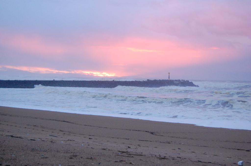
Située au nord d'Anglet, la plage de la Barre jouxte l'embouchure de l'Adour et offre le spectacle de bateaux de toutes sortes. Les blockhaus datant de la Seconde Guerre mondiale aménagés en terrasses agrémentent une promenade très pacifique. En marge de la plage, une patinoire et des lacs rendent cet endroit unique en son genre et en plein renouveau : un Skate Park, un parc d'accrobranche et le parc écologique Izadia diversifient les activités disponibles. Les surfeurs apprécient ce spot, malgré le fait que la construction de nombreuses digues au XXème siècle a souvent modifié les courants.
La proximité de l'Adour est une fréquente source de dégradation de la qualité de l'eau, en raison de pollutions domestique et industrielle.

Adjoined to the river Adour, La Barre is the most northerly beach in Pays Basque. The other side of the river is the department of Landes. Blockhouses of the Second World War have been converted into terraces around the beach. A rink, a treetop adventure park, a skate park, a forest and a lake are available close to the beach. The beach is a famous surf spot, but several dikes have been added during the twentieth century, and changes waves' characteristics.
The Adour river often brings pollution to the beach. It is the main explanation for a bad water quality.

Water Quality
  • No data available

  • Current Status
  • This status is based on the latest sample, taken on October 1st, 2018. Surfrider Foundation Europe updates the status of this beach as soon as test results become available. These results were posted to Swim Guide on October 1st, 2018 at 4:07 AM.
For water quality icon legend, click:  
Monitoring Frequency

La Barre is sampled from January 1st to December 31st.

Source Information

As part of the Watermen Testers program, Surfrider Foundation Europe volunteers monitor recreational marine and freshwater quality at several sites in the region Nouvelle-Aquitaine. The sampling season goes throughout the year, on an irregular basis depending on availability of volunteers. That is why the monitoring frequency selected is "Other" for all the beaches in the region. Priority is given to places where Watermen Testers suspect a pollution. Before (from 2014 to 2017), samples were collected bi-monthly. According to the European Directive 2006/7/CE, water quality is based on 2 bacteriological parameters: E. coli and enterococcus. Threshold between average and poor water quality :
Freshwater :
Enterococcus  660 CFU/100mL
E. coli : 1800 CFU/100mL
Marine water:
Enteroccocus : 370 CFU/100mL
E. coli: 1000 CFU/100mL

A beach is marked green if the two results (Enterococcus and E. coli) are under European thresholds.
A beach is marked red if one of the two or the two results is/are above the European threshold.
A beach is marked grey when there are no current results or there is no available information.

Special status beaches:
Due to the high frequentation of beaches during the summer and the occurrence of storms, leading to wastewater treatment plant overflows, some beaches are exposed to short term pollutions.

Uhabia – Bidart: In case of heavy rains, a valve holds untreated water at Uhabia’s estuary, and releases it 500 meters away from the coast during the night.
Grande plage – Biarritz: Sewer overflows release untreated water directly on the beach.
La barre – Anglet: This beach in mainly polluted because of Adour’s estuary which is just above, especially during floods.

Read more
Water Quality Graph

La Barre

Anglet, France

Water Quality
  • No data available
  • Current Status
  • This status is based on the latest sample, taken on October 1st, 2018. Surfrider Foundation Europe updates the status of this beach as soon as test results become available. These results were posted to Swim Guide on October 1st, 2018 at 4:07 AM.
For water quality icon legend, click:  

English below
Située au nord d'Anglet, la plage de la Barre jouxte l'embouchure de l'Adour et offre le spectacle de bateaux de toutes sortes. Les blockhaus datant de la Seconde Guerre mondiale aménagés en terrasses agrémentent une promenade très pacifique. En marge de la plage, une patinoire et des lacs rendent cet endroit unique en son genre et en plein renouveau : un Skate Park, un parc d'accrobranche et le parc écologique Izadia diversifient les activités disponibles. Les surfeurs apprécient ce spot, malgré le fait que la construction de nombreuses digues au XXème siècle a souvent modifié les courants.
La proximité de l'Adour est une fréquente source de dégradation de la qualité de l'eau, en raison de pollutions domestique et industrielle.

Adjoined to the river Adour, La Barre is the most northerly beach in Pays Basque. The other side of the river is the department of Landes. Blockhouses of the Second World War have been converted into terraces around the beach. A rink, a treetop adventure park, a skate park, a forest and a lake are available close to the beach. The beach is a famous surf spot, but several dikes have been added during the twentieth century, and changes waves' characteristics.
The Adour river often brings pollution to the beach. It is the main explanation for a bad water quality.

Monitoring Frequency

La Barre is sampled from January 1st to December 31st.

Source Information

As part of the Watermen Testers program, Surfrider Foundation Europe volunteers monitor recreational marine and freshwater quality at several sites in the region Nouvelle-Aquitaine. The sampling season goes throughout the year, on an irregular basis depending on availability of volunteers. That is why the monitoring frequency selected is "Other" for all the beaches in the region. Priority is given to places where Watermen Testers suspect a pollution. Before (from 2014 to 2017), samples were collected bi-monthly. According to the European Directive 2006/7/CE, water quality is based on 2 bacteriological parameters: E. coli and enterococcus. Threshold between average and poor water quality :
Freshwater :
Enterococcus  660 CFU/100mL
E. coli : 1800 CFU/100mL
Marine water:
Enteroccocus : 370 CFU/100mL
E. coli: 1000 CFU/100mL

A beach is marked green if the two results (Enterococcus and E. coli) are under European thresholds.
A beach is marked red if one of the two or the two results is/are above the European threshold.
A beach is marked grey when there are no current results or there is no available information.

Special status beaches:
Due to the high frequentation of beaches during the summer and the occurrence of storms, leading to wastewater treatment plant overflows, some beaches are exposed to short term pollutions.

Uhabia – Bidart: In case of heavy rains, a valve holds untreated water at Uhabia’s estuary, and releases it 500 meters away from the coast during the night.
Grande plage – Biarritz: Sewer overflows release untreated water directly on the beach.
La barre – Anglet: This beach in mainly polluted because of Adour’s estuary which is just above, especially during floods.

Read more
Water Quality Graph

  Beach Location Water Quality
Biarritz, France
Biarritz, France
Anglet, France
Anglet, France
Swim Guide
is supported by
* The RBC Foundation

Swim Guide shares the best information we have at the moment you ask for it. Always obey signs at the beach or advisories from official government agencies. Stay alert and check for other swimming hazards such as dangerous currents and tides. Please report your pollution concerns so Affiliates can help keep other beach-goers safe.

Swim Guide, "Swim Drink Fish icons," and associated trademarks are owned by SWIM DRINK FISH CANADA. See Legal.

© SWIM DRINK FISH CANADA, 2011 - 2023