Current Water Quality
No data available
This status is based on the latest sample. Swim Drink Fish - Vancouver (Formerly Fraser Riverkeeper) updates the status of this beach as soon as test results become available.
Not sampled
About Vanier Park (FRK)
Current Weather
Source Information
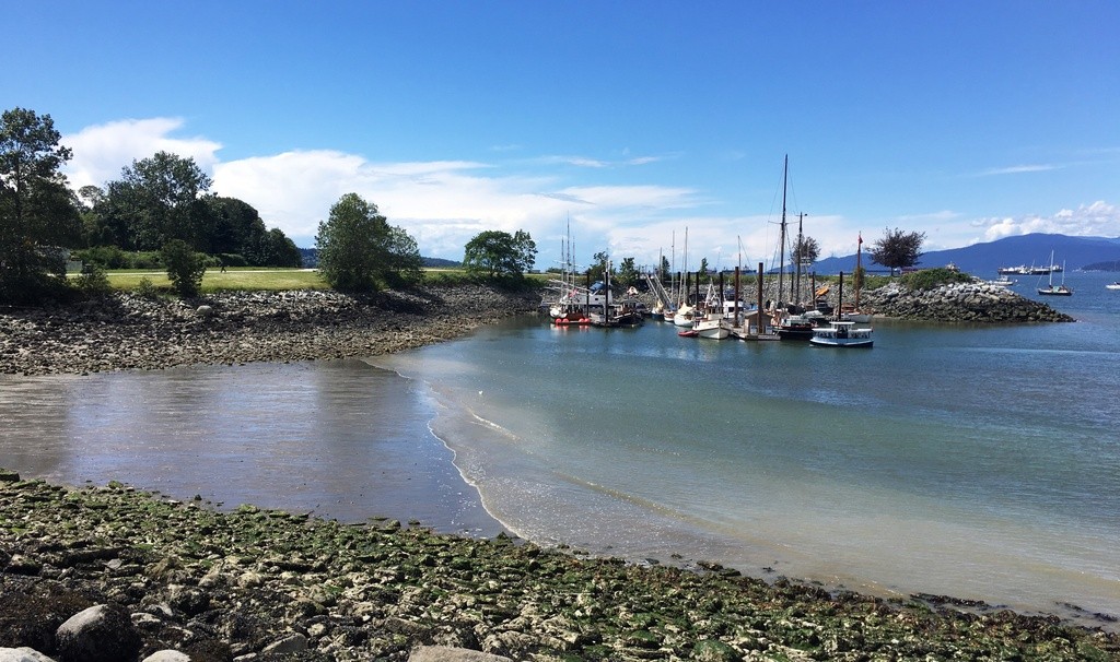
Combined Sewer Outfalls Background False Creek inlet lies at the heart of downtown Vancouver, and after undergoing a major resurgence in the past several decades, it is now a vibrant waterfront area and continues to grow. False Creek starts at the eastern end of English Bay, just at the Burrard and Granville bridges, and continues eastward almost cutting off downtown as it turns north and ends up within 1 kilometer of Burrard Inlet on the east side of the downtown core. False Creek showcases live entertainment, shopping and the art mecca of Granville Island. It is surrounded on all sides by housing of all types with designated areas for pleasure boats at marinas and public moorings. Much of the shoreline has a public promenade that includes the Stanley Park Seawall and the Coal Harbour walks. False Creek is an especially popular boating area for many different activities including dragon boating, canoeing, kayaking, public ferries, charter ships, and visiting pleasure boats. Every June, thousands of paddle-wielding racers fill False Creek for the annual Dragon Boat Festival. The Vancouver College Rowing Team holds most of its practices at False Creek, and it is home to the major sporting venues in Vancouver, including GM Place (home to the Vancouver Canucks) and BC Place (home to the BC Lions). False Creek is also home to the 2012 Winter Olympic Athletes Village. Issue Statement Waterbodies define our communities. They are the reason we have settled here. They are the reason we have prospered here. Public rights to access, swim, recreate and fish in our waters are the most ancient rights we have, and every day in every waterfront community in BC, people enjoy these rights. It is the City’s responsibility to keep sewage and polluted runoff out of public waterways. Unfortunately, False Creek remains a sewage dumping ground mainly because antiquated combined sewage outfalls, or CSOs, discharge into the inlet. CSOs are fed by outdated lines where sewage and storm water flow through a single pipe. A combined sewer system collects domestic sewage, industrial wastewater and storm water runoff. In dry weather the pipe carries all its content to a sewage treatment plant, but during heavy rainfall events, the system is overwhelmed by the high volume of flow in the system which can exceed its capacity. The sewage and the storm sewers combine and overflow into the creek, called a combined sewer overflow. In the event of a CSO, excess wastewater is discharged untreated directly into local water bodies, being a contributing source of water pollution. According to the BC government, water is considered unsafe to touch when it reaches a level of 200 coliform bacteria per 100 millilitres of water. After the 2008 False Creek sewage spill, the coliform count in the east end of False Creek shot to a reading of 2,900. Within a few days it had subsided to about 1,500, which is still more than seven times the recommended safe level. These high coliform counts once again point out the inadequacy of the region’s Liquid Waste Management Plan. The current Plan does not call for the conversion of the CSOs in False Creek until 2020. That is simply too long to continue pumping raw sewage into False Creek. The presence of coliform bacteria in aquatic environments indicates that the water has been contaminated with human or animal fecal material. Source water may also be contaminated by pathogens or disease producing bacteria including typhoid fever, viral and bacterial gastroenteritis, and hepatitis A. The presence of fecal contamination is an indicator that a potential health risk exists for individuals exposed to this water. In 1978, a Sewer Separation Program was established in British Columbia with the intent of reducing CSOs and pollution discharge into local waterways and improving the overall water quality level. It has since become a provincial requirement that all CSOs be eliminated, but not until the year 2050. The Downtown Granville and Yaletown areas are now fully separated, but the False Creek area still remains a major area of concern as overflows into that inlet are not scheduled to be eliminated until 2020. The Greater Vancouver Regional District (GVRD) has been assessing the environmental concerns and management problems associated with CSOs as part of their long range Liquid Waste Management Plan (LWMP). There are currently 52 CSO outfalls in the region with some of the major outfalls having 100-150 discharge events/yr concentrated in the winter months. According to the LWMP, No new combined sewers will be constructed in the GVRD geographic area, and existing combined sewers will be replaced by separate sanitary and storm sewers through infrastructure replacement and sewer capacity upgrading programs. While the official policy of the GVRD is to eliminate all combined sewer overflows from its facilities, with priority given to reducing or eliminating those combined sewer overflows identified by the Environmental Monitoring Committee as having significant environmental impact, pollution in False Creek is still a constant problem. Sewage overflows into False Creek occur frequently, and result in public health warnings by Vancouver Coastal Health, advising people not to touch the water after outfalls discharged raw sewage into the narrow inlet. Project Goals and Objectives Fraser Riverkeeper will bring the public's attention to the city's over-burdened Combined Sewer overflows (CSOs) on False Creek. FRK wishes to advise the GVRD, the City of Vancouver and the Provincial Government to adhere to the GVRDA¬’s Liquid Waste Management Plan and commit to the conversion of the False Creek’s CSOs. FRK Intends to develop a water quality monitoring program to help monitor the health of the aquatic habitat adjacent to the sewer outfalls. As the monitoring program is developed, community outreach, public education and advocacy activities will be undertaken. Goals: 1. Goal is a swimmable False Creek 2. CSO separation will remain a priority under GVRD’s LWMP on False Creek. 3. Develop the political will to achieve these goals by building public awareness. Fraser Riverkeeper has developed a three-pronged program to address the pollution problems in False Creek that stem from CSOs (FRK suggests key targets for bringing the city’s system into compliance with provincial water quality standards) and to reach the program’s stated goals: 1. Generate community awareness FRK would like to visit the CSO sites on False Creek and conduct a survey of a community impacted by storm sewer and combined sewer overflows. Issue surveys that assess whether people in the False Creek area swim, fish, boat, or otherwise use and enjoy the waters of the region, and specifically how and where. These uses should be protected and supported, not eliminated. FRK will compile data on beach postings and investigate whether beaches fail to meet the provincial standard. Data on sewage pollution that have resulted in health advisories will be compiled. Information for the pubic on where to look for beach closure information and advisories, as well as where the signage is located indicating CSOs, will be provided. 2. Create a False Creek Community Committee on CSOs FRK will develop a community committe on CSOs and will hold quarterly or annual meetings.... 3. Engage in Combined Sewer Overflow Monitoring Chronic CSO overflows impact boaters and pervasive odours discourage tourists. Combined sewer overflow volumes are supposed to be monitored and tended at all outfalls under the District’s jurisdiction to measure the effect and progress of combined sewer replacement programs. Environmental monitoring and assessment are supposed to determine risks and the need for any additional interim measures at combined sewer outfalls. FRK will sample pipes and surface water for evidence of sewage pollution, and document our work. Our sample results will be compared to Provincial Water Quality Objectives, which serve as guidelines for representing a satisfactory level of bacteria for surface water. FRK will perform bacteria tests for E. Coli and see whether the total coliform levels are above the Provincial Water Quality Objectives. For those outfalls that are located in areas not accessible to the public, FRK will rely on sampling data obtained through a freedom of information request to the city of Vancouver. Major Industry The Fraser River has always been heavily exploited by human activities, especially in its lower reaches. Its banks contain fertile farmland, and its water is used by pulp mills, and a few dams on some tributaries provide hydroelectric power. In the lower mainland, the base of the Fraser hosts a wide array of industry including, cement factories, water treatment facilities, and metal manufacturers. Fraser Riverkeeper is making the locations of these major industry sites available on Swim Guide, in case of a spill or accident that could affect the water quality of the Fraser.
Beaches Near This One
SEE All