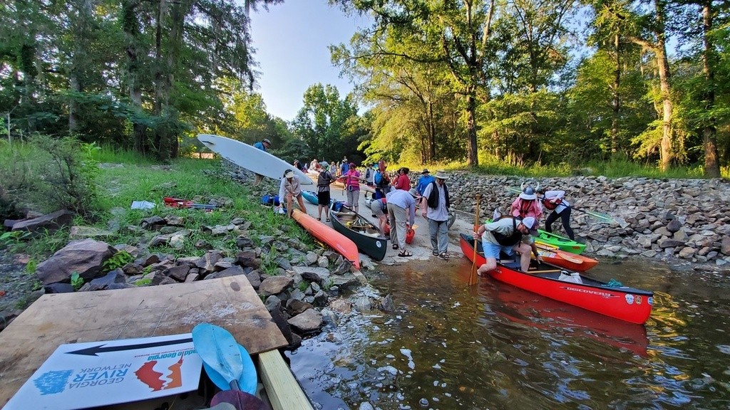
This GA-DNR boat ramp in a local park, just west of the most populous city in the Suwannee River Basin, is the last access to the Little River and often the first access to the Withlacoochee River, which is only a couple thousand feet downstream. It's about 11 river miles downstream past the Little River Confluence and the clean treated water outfall of the Valdosta Withlacoochee Wastewater Treatment Plant to US 84 Landing, which is the roughest takeout on the WLRWT. Troupville Boat Ramp is also a good takeout after 6.72 Withlacoochee River miles downstream from Langdale Park Boat Ramp. Remember to turn right at the Little River Confluence to paddle those last couple thousand feet upstream.
Troupville was the former county seat of Lowndes County, Georgia, between the blackwater Little and Withlacoochee Rivers.
In 1860 the entire town picked up and moved four miles east to the path of the first railroad, and renamed itself Valdosta..
Directions: from Valdosta, go west on St. Augustine Road west across I-75. From I-75, take exit 18, go west, and when you see a sign and traffic light for Val Tech Road, turn left instead, and that takes you down to the boat ramp.
This is a Georgia Department of Natural Resources (DNR) boat ramp operated by Valdosta-Lowndes County Parks and Recreation Authority, in a 49.36-acre park. Local elected officials are raising funds to buy the 74 acres from there down to the Little River Confluence, to make a combined 123-acre park and to build the Troupville River Camp proposed by WWALS, here at the center of the Withlacoochee and Little River Water Trail. http://wwals.net/2019/11/05/troupville-river-camp-center-of-little-and-withlacoochee-river-water-trail-2019-10-31/
The concrete boat ramp is on a dirt access road, with plenty of paved parking.
There is plenty of room for picnicking, but no facilities.
Also known as Little River Boat Ramp (Old VLPRA), or Troupville Landing (after the name of the old Lowndes County seat), or Troupeville Landing (GDOT). Often called the prison boat ramp after the state prison across the road.
Photo: John S. Quarterman at the start of #PaddleGA2019. http://wwals.net/?p=49589
For more about Troupville Boat Ramp:
http://wwals.net/maps/withlacoochee-river-water-trail/wrwt-map/wrwt-access/#Troupville-Boat-Ramp
Keep your distance from other people.
Practicing social distancing is still essential. Only go to the beach if you are able to keep 6 feet or 2 meters away from others. Follow the instructions provided by your local health authorities. If your community has asked that you remain indoors and away from others, do so. Spending a day in any crowded place is the worst thing we can do for our most vulnerable right now and will counter our efforts to curb the virus’s spread.
This GA-DNR boat ramp in a local park, just west of the most populous city in the Suwannee River Basin, is the last access to the Little River and often the first access to the Withlacoochee River, which is only a couple thousand feet downstream. It's about 11 river miles downstream past the Little River Confluence and the clean treated water outfall of the Valdosta Withlacoochee Wastewater Treatment Plant to US 84 Landing, which is the roughest takeout on the WLRWT. Troupville Boat Ramp is also a good takeout after 6.72 Withlacoochee River miles downstream from Langdale Park Boat Ramp. Remember to turn right at the Little River Confluence to paddle those last couple thousand feet upstream.
Troupville was the former county seat of Lowndes County, Georgia, between the blackwater Little and Withlacoochee Rivers.
In 1860 the entire town picked up and moved four miles east to the path of the first railroad, and renamed itself Valdosta..
Directions: from Valdosta, go west on St. Augustine Road west across I-75. From I-75, take exit 18, go west, and when you see a sign and traffic light for Val Tech Road, turn left instead, and that takes you down to the boat ramp.
This is a Georgia Department of Natural Resources (DNR) boat ramp operated by Valdosta-Lowndes County Parks and Recreation Authority, in a 49.36-acre park. Local elected officials are raising funds to buy the 74 acres from there down to the Little River Confluence, to make a combined 123-acre park and to build the Troupville River Camp proposed by WWALS, here at the center of the Withlacoochee and Little River Water Trail. http://wwals.net/2019/11/05/troupville-river-camp-center-of-little-and-withlacoochee-river-water-trail-2019-10-31/
The concrete boat ramp is on a dirt access road, with plenty of paved parking.
There is plenty of room for picnicking, but no facilities.
Also known as Little River Boat Ramp (Old VLPRA), or Troupville Landing (after the name of the old Lowndes County seat), or Troupeville Landing (GDOT). Often called the prison boat ramp after the state prison across the road.
Photo: John S. Quarterman at the start of #PaddleGA2019. http://wwals.net/?p=49589
For more about Troupville Boat Ramp:
http://wwals.net/maps/withlacoochee-river-water-trail/wrwt-map/wrwt-access/#Troupville-Boat-Ramp
Swim Guide shares the best information we have at the moment you ask for it. Always obey signs at the beach or advisories from official government agencies. Stay alert and check for other swimming hazards such as dangerous currents and tides. Please report your pollution concerns so Affiliates can help keep other beach-goers safe. Swim Guide, "Swim Drink Fish icons," and associated trademarks are owned by SWIM DRINK FISH CANADA. See Legal.
© SWIM DRINK FISH CANADA, 2011 - 2023